CREAF / Meteoclimática. Marzo de 2025 - presente

Meteoclimática. How to talk about climate change in TV's weather forecasts

Meteoclimática. Cómo hablar de cambio climático en los espacios del tiempo en televisión

In Meteoclimática, our goal is mainly one: to encourage meteorologists to include climate change related topics in TV's weather forecasts. With this we want to introduce a topic in a space that viewers (more and more digital) still consult almost daily and leaded by presenters that have their trust. The project grows more and more important considering the thoughts on climate change that are spread nowadays in social media and that make the topic, not so controverted few years ago, the key for many voters and political parties supporters.

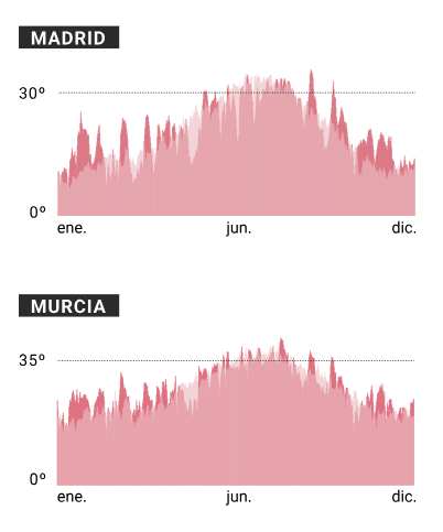
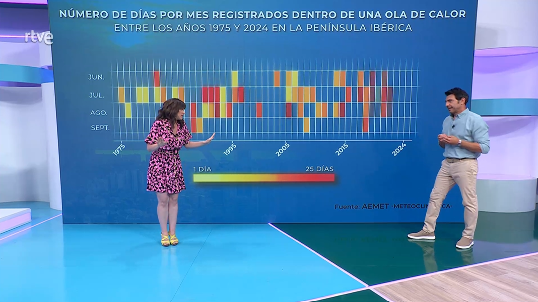
Creating graphics for television is a hard task, considering the little time that meteorologists have and the reduced attention span that viewers present. Also, topics can be a bit controversial sometimes. We always try to make things as simple as possible and rely on open sources, like AEMET or Copernicus. The data that we extract is later analysed, all things considered, and later transformed into simple static graphics that the general public can easily understand and absorb, creating the highest impact. Link to article

El Confidencial. Octubre 2022 - enero 2025

Where is sea water colder, in Llanes or in Marbella? We have a full guide to explain it

¿Dónde está más fría el agua, en Llanes o en Marbella? Tenemos la guía de baño definitiva

For the summer season, we explored sea surface temperatures across all Spanish coastal municipalities. Using a dataset with 0.5° spaced points, we aggregated the average water temperatures by municipality and province. We also analyzed historical records of maximum and minimum sea temperatures. This data allowed us to provide a comprehensive view of coastal water conditions, helping readers understand regional variations. The article emphasized how the changing water temperatures can affect tourism and local activities, particularly in popular summer destinations. Additionally, it shed light on broader environmental trends, linking the findings to potential impacts of climate change on Spanish coastal regions.

The data for sea temperatures were extracted via the Copernicus Marine Service API using a command-line library. All data analysis was conducted in Python, utilizing xarray to open .nc files, and pandas and geopandas for cleaning geographic files and grouping data by months. To link the geographic points from the dataset with municipal polygons, a proximity join function in QGIS was used. This combination of tools allowed for a precise analysis of sea surface temperatures, providing detailed results for each Spanish coastal municipality. Link to article

Why do you not recognize any song from the most streamed artist worldwide?

The map of European population: do you live in the most populated square kilometre of the continent?

The water games that can dry out Europe's pantry

Chronic of an announced infidelity: el lenguage of "Temptation Island" gives out the cheaters

Where do your neighbours work? The map of all mandatory journeys for each town in Spain

The map of heat expenditure, building by building: do you pay more that your neighbours?

Up to 122 with the AC on: this is how what your electricity bill will look like, depending on where you live